Abergavenny: Difference between revisions
No edit summary Tag: sourceedit |
No edit summary |
||
| (11 intermediate revisions by 5 users not shown) | |||
| Line 1: | Line 1: | ||
{{wikipediainfo}} | {{wikipediainfo}} | ||
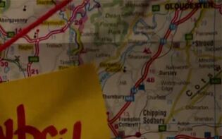
'''Abergavenny '''was a town to | {{first pic|Gloucester and Stroud map (TCOL).jpg|Mary Cooper's map, showing the location of Abergavenny. ([[TV]]: {{cs|The Categories of Life (TV story)}})}} | ||
'''Abergavenny '''was a town in the south-east of [[Wales]]. | |||
Nearby towns included [[Pontypool]] to the south and both [[Ebbw Vale]] and [[Abertillery]] to the south-west. Local small towns and villages included [[Blaenavon]] to the south-west, [[Crickhowell]] to the north-west and [[Raglan]] to the south-east. To the west of the town was a [[national park]]. Abergavenny was situated on the [[River Usk]], and located at the intersection between the [[A40]] and the [[A465]]. A [[railway]] ran through Abergavenny. ([[TV]]: {{cs|The Categories of Life (TV story)}}) | |||
[[Andy Davidson]] jokingly suggested [[Weevil]]s were fleeing to Abergavenny. ([[TV]]: {{cs|Exit Wounds (TV story)}}) | |||
Abergavenny appeared on [[Mary Cooper]]'s map of [[overflow camp]]s in and around [[Wales]]. ([[TV]]: {{cs|The Categories of Life (TV story)}}) | |||
== Behind the scenes == | |||
Although unnamed in ''[[The Categories of Life (TV story)|The Categories of Life]]'', in the real world the national park seen on the map to the west of Abergavenny is the [[Brecon Beacons]]. | |||
[[Category:Welsh towns and villages]] | [[Category:Welsh towns and villages]] | ||
[[Category:Towns and villages from the real world]] | |||
Latest revision as of 20:57, 17 August 2024

Abergavenny was a town in the south-east of Wales.
Nearby towns included Pontypool to the south and both Ebbw Vale and Abertillery to the south-west. Local small towns and villages included Blaenavon to the south-west, Crickhowell to the north-west and Raglan to the south-east. To the west of the town was a national park. Abergavenny was situated on the River Usk, and located at the intersection between the A40 and the A465. A railway ran through Abergavenny. (TV: The Categories of Life [+]Loading...["The Categories of Life (TV story)"])
Andy Davidson jokingly suggested Weevils were fleeing to Abergavenny. (TV: Exit Wounds [+]Loading...["Exit Wounds (TV story)"])
Abergavenny appeared on Mary Cooper's map of overflow camps in and around Wales. (TV: The Categories of Life [+]Loading...["The Categories of Life (TV story)"])
Behind the scenes[[edit] | [edit source]]
Although unnamed in The Categories of Life, in the real world the national park seen on the map to the west of Abergavenny is the Brecon Beacons.
